About ALOS-2
The Advanced Land Observing Satellite-2 (ALOS-2) is follow-on mission from the “DAICHI”, which contributed to cartography, regional observation, disaster monitoring, and resource surveys. ALOS-2 will succeed this mission with enhanced capabilities. Specifically, JAXA is conducting research and development activities to improve wide and high-resolution observation technologies developed for DAICHI in order to further fulfill social needs.
Specs
| Sensor | SAR | |
|---|---|---|
| PALSAR-2(Frequency) | L-band (1.2 GHz band) | |
| Observation mode | Spotlight | Resolution:1×3m Swath:25km |
| Strip Map | Resolution:3m~10m Swath:50km,70km |
|
| ScanSAR | Resolution:60~100m Swath:350km |
|
| Orbit | type | Sun-synchronous quasi-return orbit |
| Altitude | 628km | |
| Descending point local time | 12:00 (noon) | |
| Return days | 14 days | |
| Design life | 5 years (target: 7 years) | |
| Satellite mass | Approx. 2,100 kg | |
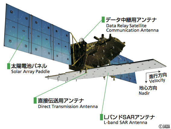
| Mission data transmission | Direct transmission, and via data relay satellite | |
| Launch date | 2013 | |
| Launch vehicle | H-IIA launch vehicle No. 24 | |
Observation Modes
| Observation Mode | Range Resolution | Azimuth Resolution | Scene Size | Polarimetry |
|---|---|---|---|---|
| Spotlight | 3.0m | 1.0m | 25km x 25km | Single (HH or HV or VH or VV) |
| Ultra-Fine | 3.0m | 3.0m | 55km x 70km | Single (HH or HV or VH or VV) Dual (HH + HV or VH + VV) |
| High-sensitive | 6.0m | 4.3m | 55km x 70km | Single (HH or HV or VH or VV) Dual (HH + HV or VH + VV) |
| Fine | 9.1m | 5.3m | 70km x 70km | Single (HH or HV or VH or VV) Dual (HH + HV or VH + VV) |
| High-sensitive (Full Polarimetry) | 5.1m | 4.3m | 30km x 70km | Quad (HH + HV + VH + VV) |
| Fine (Full Polarimetry) | 8.7m | 5.3m | 30km x 70km | Quad (HH + HV + VH + VV) |
| ScanSAR nominal (28Mhz) | 47.5m (5 look) | 77.7m (3 look) | 350.5km x 355km | Single (HH or HV or VH or VV) Dual (HH + HV or VH + VV) |
| ScanSAR nominal (14Mhz) | 95.1m (5 look) | 77.7m (3 look) | 350.5km x 355km | Single (HH or HV or VH or VV) Dual (HH + HV or VH + VV) |
| ScanSAR wide (490km) | 44.2m (2 look) | 56.7m (1.51 look) | 489.5km x 355km | Single (HH or HV or VH or VV) Dual (HH + HV or VH + VV) |
※ The values are defined at the incidence angle of 37 degrees.