NTT DATA and RESTEC Launch AW3D Full Global 3D Map with 2.5-meter Definition
Tokyo, July 1, 2019 ? Remote Sensing Technology Center of Japan (RESTEC), the heart of the remote sensing industry, and NTT DATA, a leading IT services provider, announced today that they have begun selling AW3D Standard (2.5m resolution), a highly precise, pre-produced digital-elevation-model 3D map of the world. AW3D Standard, which first launched with five-meter resolution in 2014, is currently used in more than 115 countries.
This latest version of AW3D Standard, which offers 2.5-meter resolution for extra-detailed expression of cities and terrain, will be utilized for a wide variety of global applications.RESTEC and NTT DATA will use AW3D Standard (2.5m resolution) to provide clients with value-added information for urban planning, disaster-damage forecasting, and much more, including customized maps for specific locations and purposes.
Going forward, AW3D will continue to be upgraded and integrated with geospatial-information systems of other partners. The AW3D lineup also includes AW3D Enhanced, AW3D Ortho Imagery, AW3D Building, AW3D Telecom and AW3D Airport, in addition to AW3D Standard. RESTEC and NTT DATA are targeting total AW3D sales of 5 billion yen (USD 46.2 million) in fiscal 2022.
About AW3D Standard (2.5m resolution)
This latest version of AW3D Standard digital 3D maps offers 2.5m resolution. The mapping process uses a floating-point format for height values to achieve highly accurate representations of terrain, including smooth expressions of topography. Compared to 5m resolution, 2.5m resolution offers:
・ Fine expression of terrain undulations
・ Expression of coastal landfills, narrow rivers and waterways
・ Urban structures such as buildings and overpasses
・ Flat structures such as roads
Katsuichi Sonoda, Senior Vice President and Head of NTT DATA’s Social Infrastructure Solution Sector, said: “This newest version, which is believed to be the world’s highest-definition digital map covering the entire globe, presents views of the world with unprecedented clarity, creating opportunities for extra-wide application in diverse industries and government-level projects.”
Kaname Ikeda, President of RESTEC said: “AW3D Standard (2.5m resolution) represents a significant step forward in the innovative use of Japan’s cutting-edge space technology. This new version will enable companies, organizations and governments to achieve the United Nation’s Sustainable Development Goals (SDGs) for industry, innovation and infrastructure (Goal 9), sustainable cities (Goal 11), climate action (Goal 13) and goal partnership (Goal 17).”
Usage examples
AW3D Standard (2.5m resolution) supports very accurate simulations and analyses for urban planning and natural-disaster prediction. Offering accuracy equivalent to a map scale of 1/25,000, AW3D Standard (2.5m resolution) is suitable for use as core map information by national governments.
| Purpose | Usage (examples) |
|---|---|
| Climate change | ・ Flood and storm surge damage analysis & creation of hazard maps ・ Investigations of impact of sea level rise ・ Creation of landslide disaster hazard maps |
| Urban planning | ・ Creation of topographic maps on a national scale ・ Development of urban planning master plans ・ Planning construction sites for large-scale infrastructure and routes |
| Health, water and sanitation | ・ Watershed analysis ・ Ground water research by topographical analysis and well-drilling site selection ・ Identification of virus-infection routes through flow analysis |
| Innovation | ・ Planning flight plans for aircraft, helicopters and drones ・ Enhancement of car navigation ・ Wireless network design simulations ・ Correction of remote sensing data in satellite imagery and aerial photographs |
| Marine and land resources | ・ Selection of promising areas for mine development ・ Geothermal energy research |
| Energy | ・ Simulation of suitable sites for wind and solar power generation |
| Education | ・ Production of videos using computer graphics ・ Production of education materials for geography and disaster prevention |
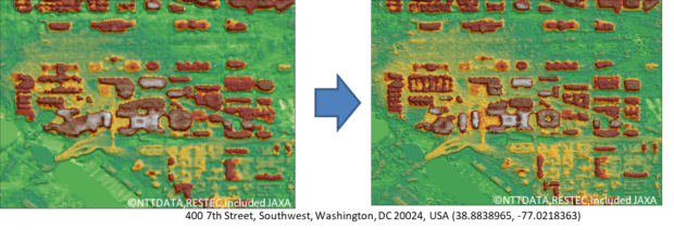
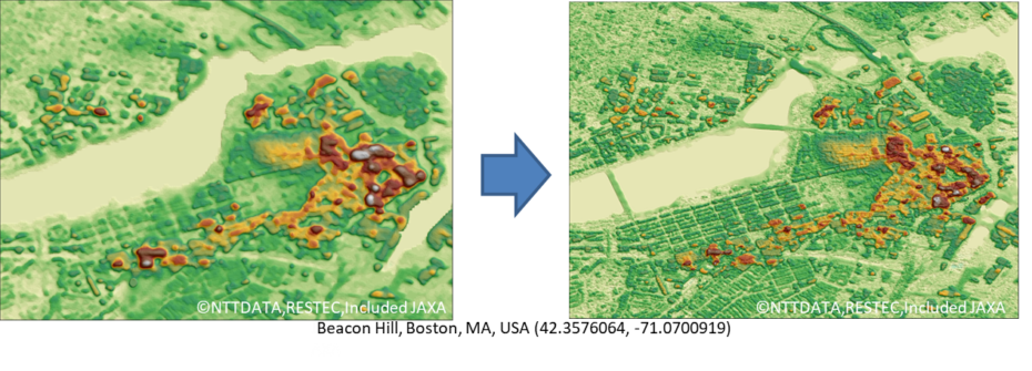
Resolution comparison


Prices
Starting at USD 5 per km2 for less than 10,000 km2
About AW3D
RESTEC and NTT DATA Japan introduced the world’s first digital-elevation-model (DEM) 3D maps with five-meter resolution in February 2014. Created from some three million satellite images taken with the DAICHI Advanced Land Observing Satellite (ALOS)* of the Japan Aerospace Exploration Agency (JAXA), the digital 3D maps express the topography of the entire world.
Current AW3D developmental efforts include extracting information with artificial intelligence and other cutting-edge technologies to enable customers to shorten work schedules and lower costs.
AW3D has been used in over 900 projects in more than 115 nations, mainly emerging countries, helping to meet needs related to infrastructure, disaster prevention, etc. for economic development and societal progress. Please visit http://www.aw3d.jp/en/.
*Launched from Japan in 2006 and operational for five years, the satellite was used for high-definition global observations, supporting the creation and updating of maps, analysis of disaster scenarios, regional environmental observation and more. A panchromatic remote-sensing instrument for stereo mapping (PRISM) took some 6.5 million images, of which about three million could be used due to minimal cloud coverage.
AW3D is a registered trademark of RESTEC and NTT DATA in Japan, and a registered trademark of NTT DATA in Europe (EUTM) and the United States.
Other product names, company names and corporate names are their trademarks or registered trademarks.