Ocean
Surveying Wider Areas of Global
Oceans and Smaller Localized Areas of Ocean
- About 70% of the earth’s surface is covered with water. It is becoming increasingly important for Japan, an island nation surrounded by oceans, to monitor the conditions out at sea, in the interests of safeguarding its fishing industry, physical distribution routes, and isolated islands as well as monitoring environmental problems. Earth observation satellites are useful tools that enable extensive, detailed and regular surveying of wide areas of ocean.
-
Tsutomu Yamanokuchi, Ocean Team Leader
Northern Sea Route: Monitoring Sea Ice to Contribute to Safe and Cost-efficient Navigation for Shipping
In recent years, the sea ice in the Arctic Ocean has been declining, with its area reaching the smallest in observed history in September 2012. The shrinking of sea ice is a concern because of its implications for climate change. On the other hand, it is opening up the possibility of putting Northern Sea Routes into practical use. Compared to traditional shipping routes further south, the Northern Sea Route cuts time and fuel costs. There is also possibility that the route can be used to transport resources from Siberia, a treasure trove of natural resources. As such, many people across the globe are looking to the Arctic Ocean with great expectations.
However, to navigate in the Arctic Ocean the sea ice must be constantly monitored. This is where earth observing satellites come into play. Using satellite data allows sea ice to be finely ascertained over an extensive area. Using this satellite information in combination with meteorological data, initiatives are underway to predict the short, mid and long term state of sea ice across the entire shipping route.
There are two types of ice, with one type melting in a year, and the other type remaining for over a year, known as “multiyear ice.” Earth observing satellites are able to differentiate between the different types, and can plan shipping schedules in response to ever-changing conditions. There is also a possibility that these satellites can be used to monitor the environment, such as environmental pollution caused by oil leaking from ships.
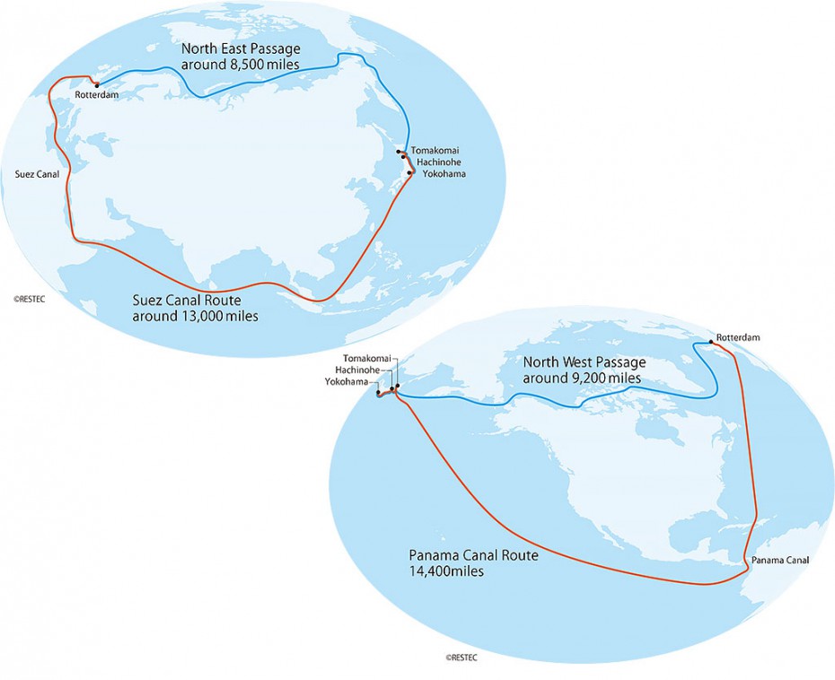
The Northern Sea Route: The southern shipping route (indicated in red in the diagram) that passes through the Panama Canal is the shipping route normally used to connect Japan with Europe. If the Arctic Ocean shipping route (indicated in blue) that passes to the north of the Eurasian continent could be used, it would cut travel time to around two-thirds of its current total, significantly saving time and fuel. It would also avoid passing near Somalia, reducing the risk of being attacked by pirates. This has resulted in a rising tendency all around the world to take advantage of this shipping route in the summer when there is little ice.