Infrastructure
Social infrastructure such as railways, roads, levees, as well as water, gas, and power systems are characterized by their networks that cover long distances and extend across the entire country and by the scattering of related facilities.
While such infrastructure are maintained through daily and routine inspections, there are concerns over the decline of their bearing force due to aging and damage caused by major earthquakes, ground subsidence, and landslides.
To protect social capital and the properties of individuals, there is an urgent need to strengthen and increase the efficiency of systems for maintaining structures as well as ground and geological conditions across the entire lifecycle of social infrastructure.
The characteristics of satellites, namely wide coverage and periodicity, can be leveraged to efficiently monitor the infrastructure network and its peripheral grounds. Such monitoring can compensate the daily and routine inspections that are usually conducted and detect risks that inspections cannot discover, and in turn, contribute to strengthening and increasing the efficiency of maintenance systems.
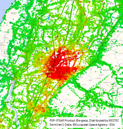
Road and railway
-
In this example, ground subsidence over a wide area and the associated displacement of roads and railways are shown visually. This image was created by analyzing data collected from a satellite-mounted synthetic aperture radar (SAR) using a technique called time-series interferometric SAR.
Using this technique, infrastructure networks such as roads, railways, and related facilities and their peripheral grounds can be inspected at once.
With this technique, we can use measurements of areas where people cannot enter and areas where sensors cannot be installed, along with observation data accumulated over several decades. It is thus possible to conduct analyses that go back in time. If a daily or routine inspection finds an abnormality or risk, it is possible to analyze and assess when the abnormality occurred.
While the measurements are slightly less precise compared to measurements taken on the ground and laser measurements, displacement can be measured with millimeter accuracy.
The technique can be utilized for screening the situation of ground displacement and for complementing ground measurements.
As part of its earth surface displacement measurement service, RESTEC provides results of measurements using this technique.
-
Airport
-
The above technique for social infrastructure like roads and railways can be applied for airport monitoring as in this example. As the image shows, measurements can be taken even of runways where there are restrictions on the people who can enter and conduct surveys.
Aerial and satellite photos taken in the past can be integrated to create visual representations. Doing so shows that the area of the ground subsidence corresponds to the area of airport expansion by reclamation.
It also shows clearly that there is subsidence of quays and offshore structures in the distance. -
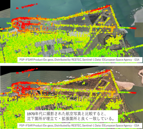
The background images source is Geospatial Information Authority of Japan: "Simple Aerial photography(2004~)"(above), "National land image information(1974~1978)"(below)